Content created: 1996-10-11, revised 2010-09-03
File last modified:
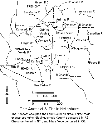
It is a pet peeve of mine that many (most?) works on the Southwest make reference to its many river valleys, but do not include an over-all reference map. The simplified reference map on this page identifies the major river valleys along which the Anasazi (Ancestral Puebloans) and their neighbors settled. If you print it out, it should fit comfortably on a notebook page.
The map shows all of Artizona and parts of (clockwise from the upper left) Utah, Colorado, and New Mexico. The area around the point where all four states converge is referred to as the "Four Corners," and is conveniently considered to be the heart of Anasazi territory.
The Hopi (“Western Pueblo”) reservation is in northern Arizona. “Eastern Pueblo” reservations are in New Mexico. The Tewa are between these groupings. These Puebloan groups are usually considered to be the modern descendants of the ancient peoples listed on the map.
Note that all the rivers of the area ultimately are part of three great river systems:
