The survey covered (thinly) a huge area, and I have not posted detailed maps of the region. I do have 1:200,000 scale topographic maps of the area covered and if anyone is interested in copies, please contact me directly.
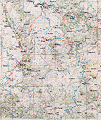
This regional map indicates the major towns, and the approximate route of my survey (at least, the towns I stayed at). The map is old; it shows the main road to Kenieba originating in Mahina, but when I was there the Mahina end was gone and we drove south from Kayes (not shown, NNW of Kenieba). Evidence of chimpanzees was encountered at essentially all stops south of Kassama (13° 30'N) where we looked seriously.
If you have any trouble downloading the image, let me know and I will see what I can do.
| Click for 1.4MB version |